| Weather Data | |||
|---|---|---|---|
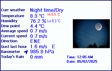
| LAST READING AT TIME: 2:40 PM DATE: April 26 2026, time of next update: 2:45 pm | |||
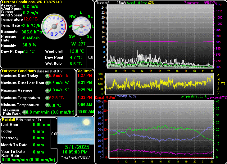
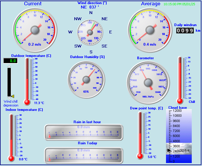
| Current Weather | Dry | Current Temperature | -1.1°C (30.0°F), Apparent temp -4.4°C |
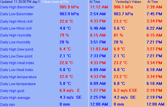
| Maximum Temperature (since midnight) | -100.0°C at: 2:10 AM | Minimum Temperature (since midnight) | 100.0°C at: 2:10 AM |
| Average windspeed (ten minute) | 1.5 m/s | Wind Direction (ten minute) | SSW (202°) |
| Windchill Temperature | -3.3°C | Maximum Gust (last hour) | 0.0 m/s at: 2:00 PM |
| Maximum Gust (since midnight) | 0.0 m/s at: 2:10 AM | Maximum 1 minute average (since midnight) | 0.0 m/s at: 6:43 PM |
| Rainfall (last hour) | 0.0 mm | Rainfall (since midnight) | 0.0 mm (0.00 in.)--- |
| Rainfall This month | 0.0 mm (0.00 in.) | Rainfall To date this year | 0.0 mm (0.00 in.) |
| Maximum rain per minute (last hour) | 0.0 mm/min | Maximum rain per hour (last 6 hours) | 0.0 mm/hour |
| Yesterdays rainfall | 0.0 mm | DewPoint | -10.0°C (Wet Bulb :-3.6°C ) |
| Humidity | 50.9 %, Humidex -5.1°C | Barometer corrected to msl | 989.0 hPa |
| Pressure change | 0.0 hPa (last hour) | Trend (last hour) | STEADY |
| Pressure change (last 12 hours) | +0.0 hPa | Pressure change (last 6 hours) | +0.0 hPa |
Use the RELOAD facility on your browser to retrieve the latest data.